
Construction Surveying: Plotting the Foundation of Every Build


Last Updated Jul 24, 2026
Carlo Carollo
Carlo Carollo is a Survey and Data Manager at RNGD, specializing in heavy civil construction. Since July 2023, he has been responsible for overseeing surveying and data management activities. Before joining RNGD, Carlo worked for Boh Bros. Construction Co., LLC as a Layout Party Chief. He is based in New Orleans, LA.
Trey Strange
Contributing Writer
28 articles
Trey Strange is a Peabody and Emmy-Award winning writer and producer based in Brooklyn, NY. Throughout his career, Trey has worked for the Huffington Post, Houston Chronicle, Out Magazine, Brooklyn Eagle, CNBC, INTO, and New York Magazine's Bedford + Bowery. He received his Masters in Journalism and Middle East studies from New York University, and Bachelors in the same subjects from the University of Houston.
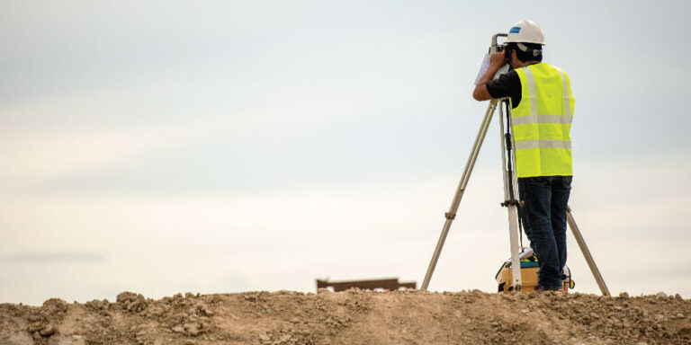
Construction wouldn’t be possible without surveyors, whose work serves as the foundation for all accurate worksite development. Construction surveying involves accurately measuring and mapping the environment where infrastructure or buildings will be, or have been, built. Construction surveyors provide project teams with horizontal and vertical references to ensure a project is built according to design plans and specifications.
Without proper surveying, projects risk significant errors, misalignments and costly rework. Surveyors gather the essential data needed for planning, designing and executing construction.
Understanding the role of the surveyor is important for project teams and anyone in construction management to prevent mistakes.
This article explores the unique features of construction surveying — including types of surveys, challenges with completing a survey and best practices for getting it done right.
Table of contents
Types of Surveys in Construction
Construction surveying includes several different types of surveys that are done at different times in the project life cycle and for different reasons, such as boundary surveys, topographic surveys, and as-built surveys, among others. The type of surveys needed for specific construction projects will depend on the site itself, the scope of work, the design, and other factors.
Surveyors are likely the first crewmembers to break ground on many worksites. But even before this phase, surveyors play an important role in making sure the worksite will be functional for the rest of the build.
The following lists a few types of construction surveys and some of the aspects of the job that surveyors are responsible for.
Topographic Survey
Also called a “topo,” this study involves a detailed mapping of the features and contours of a specific piece of land, including both natural elements and man-made structures (such as buildings, roads, and utility lines). A topo is usually performed early on, when a worksite’s feasibility is being determined, and before the GC is hired on.
Control Surveys
Establishing project control is one of the most important aspects of a surveyor’s role on the worksite. During preconstruction, the surveyor determines a coordinate to serve as the horizontal point of control, and a Benchmark as the vertical point of control. All other points/markings will then be measured relative to these two places, which allows for accurate, precise building.
Design Plan Surveys
These surveys collect detailed information about existing site conditions. The goal is to cross-check a set of drawings and any initial surveys to verify their accuracy. This step ensures that any discrepancies are identified and corrected before construction begins.
Staking and Layout
After confirming that a set of drawings is accurate to the intended worksite, surveyors transfer the design plans onto the construction site by marking the locations of structures, utilities, and other features with stakes, which will tell crew members where to build.
Monitoring and Adjustments
Surveyors regularly monitor project control throughout the construction process, adjusting or re-setting as needed.
As-built Surveys
Upon completion, surveyors record final as-built data, documenting the actual locations and elevations of the constructed features to ensure they have been built according to the design. These surveys are documented and provided to project stakeholders to serve as a reference for future maintenance, modifications or expansions.
Calculating Relative vs. True Elevations
Calculating relative vs. true elevations is a key element in construction surveying, with relative elevation based on a local reference point and true elevation referring to a fixed, absolute datum like sea level. When necessary, construction surveyors can calculate the difference between these two types of elevation by deducting one from the other.
While most infrastructure and heavy civil projects often have control points included in the plans, there are occasions when plan sets do not include project specific control. In these cases, a professional land surveyor (PLS) may be needed to verify or certify these benchmarks and determine the actual, or true, elevation.
Not all situations or projects require a specific, true elevation. Instead, relative elevations are often used for simplicity and practicality. For instance, on a building's plan set, the finished floor elevation might be denoted as zero, with all points above it marked as positive, and points below the elevation marked as negative. This “relative” system simplifies calculations.
In New Orleans, for example, Cairo Datum is typically used so that positive rather than negative elevation numbers are applied. For surveyors, working with negative (or true) elevation figures can introduce additional complexity to the construction process. To avoid compounding complexities in calculating elevations, relative elevations may be used. Within the scope of a particular project, what may matter most is the relative elevation — how features relate to one another rather than their precise sea-level altitude.
Challenges With Construction Surveying
Challenges in construction surveying can vary from physical issues like difficult-to-access job sites to miscalibrated surveying equipment, inaccurate designs and plans, or locating and maintaining reference points. Identifying and correcting these issues requires meticulous attention to detail and often robust communication.
When a structure is built or placed incorrectly, it’s often easy to blame the surveyor—though in reality, many mistakes on a construction site are usually the result of a miscommunication between parties, a lack of proper communication in the first place, and/or a failure to perform quality control.
The issues a surveyor might run into onsite include challenges with design plans, control points, and busts.
Design Plan Errors
A common error in a set of plans is discrepancies in alignment and elevation. One of the first steps of the surveyor’s job is to study the set of designs and check for errors. When they get to the jobsite, it’s critical to make sure the plans are accurate and up-to-date, and reflect the topography of the land they’re working on.
Because tiny problems can cascade into massive structural issues, surveyors must frequently verify both their plans and the measurements they make onsite.
Maintaining Control Points
Construction sites are dynamic spaces, and establishing and maintaining horizontal and vertical control points can be difficult in a number of ways, from human interference to environmental conditions. A heavy rain or wind can easily wash away markers, for example, or residents in the neighborhood might tamper with them, not knowing how important they are.
Surveying with control points generally requires a clear line of sight when using laser equipment and total stations. Surveying via GPS or GNSS, however, can be done without clear line of site. As construction progresses, new structures or materials can obstruct these lines of sight, making it difficult to use the existing control points. Sometimes a surveyor may need to establish new control points throughout the project as they evaluate its needs.
Busts
When an error in alignment or elevation occurs, it’s called a bust. Often a result of a high-stress environment, busting even an inch on elevation, for example, can result in incorrect heights for key structures, and can tremendously impact the structural integrity of the site later on.
Another common way to bust is to incorrectly measure the placement of critical tie-ins for utilities, which can result in time-consuming and expensive rework.
I was on a project where we had a concrete foundation that was around 300 cubic yards, and it essentially all had to be demolished and reconstructed because of Incorrect anchor bolt spacing.
In most petrochemical plants, contractors build foundations for prefabricated steel structures that fit snugly over those anchor bolts. The anchor bolts need to be very precise and match almost perfectly to the footprint of the structure being set on it. So, for a seemingly minimal error, we had to remove an entire slab of concrete.
Carlo Carollo
Surveying Licenses, Equipment & Technology
Most states and regions require construction surveyors to be trained and licensed, and while some smaller elevation surveying and similar work specific to construction might be performed by construction contractors, any survey plans and documentation will usually need to be completed by a professional land surveyor. Land surveyors use a variety of equipment including total stations and GPS, while newer technologies like drones are becoming a lot more common.
Many construction surveyors are able to perform work without licenses or certifications, depending on the requirements of the construction project, the GC may need to hire a third-party professional land surveyor who has the proper credentials.
Obtaining this license is a years-long process. Most states require an associate’s or bachelor’s in surveying, or a closely related field, after which a future PLS will need to pass several exams before receiving their state license. Generally, an internship is also required, similar to the requirements for becoming a construction engineer.
Having a PLS onboard can be necessary for the legality of the project, as they are the only ones allowed to certify elevations and mark initial property boundaries, for instance. Without a licensed surveyor, the project could face future legal challenges.
Additionally, the introduction of the robotic total station, which, in the last 15 years had been adopted by contractors for daily use, has revolutionized the workload by automating distance measurement and angle calculations. Previously, robotic total stations were primarily used by land surveyors.
The robotic total station uses Electronic Distance Measuring (EDM), and can also track the surveyor’s movements across the land, which means it effectively only needs one person to operate it, and reduces the need for the operator to be proficient in the more advanced mathematics generally required in this trade.
By streamlining the surveying process, the robotic total station enhances accuracy, reduces labor costs, and minimizes the potential for errors.
Best Practices in Construction Surveying
Best practices in construction surveying are processes and procedures that ensure maximum accuracy and efficiency, while minimizing errors and omissions. These best practices encompass strategies like meticulous documentation, regular calibration of equipment, continuing education, and fostering clear communication channels.
A surveyor’s job may require several checks to ensure accuracy. However, there are ways to help surveyors manage their processes and successfully complete these steps before and during construction.
Focus on the details.
The most important skill for a construction surveyor is being detail-oriented. The best way to prevent a bust or future rework is to check every measurement multiple times and then again frequently throughout the project. It’s also important to stay focused under pressure, as high-tension moments—such as speeding to finish a project on deadline—are when errors are most likely to happen.
Organize documents.
Good documentation is also critical, as a record of every decision may be necessary to later identify where the project went wrong. Making use of construction management software can be especially useful for this — and it’s also helpful for tracking changes to drawings and plans, which must be accurate and up-to-date in order for a surveyor to complete their job correctly.
Collaborate often.
In terms of collaborating with surveyors, project teams should clearly define the scope of the project and consistently consult with the surveyors to verify measurements and maintain project control onsite. By fostering a communicative relationship with surveyors, GCs can significantly reduce the risk of rework onsite, and smoothly advance their project to the handover phase.
Construction surveying requires critical thinking, creativity and a passion for precision. With so many risk factors at stake on projects, it’s important for surveyors to eliminate some of the guess work and ensure that project teams are equipped with the information they need to successfully execute their work.
Although attention to detail is necessary, there are several modern systems and tools available to help surveyors manage and share the information they gather with other teams.
The Indispensable Role of Surveyors in Construction
Construction surveying is an essential part of any building project, providing the foundational data needed to ensure accuracy and alignment.
General contractors and other stakeholders should recognize their vital role and support their efforts by fostering clear communication and ensuring that licensed professionals are involved when needed.
Ultimately, construction surveying requires a blend of technical skill, attention to detail, and effective use of modern tools. By understanding and supporting the work of surveyors, construction projects can achieve higher accuracy, reduced rework, and successful outcomes.
Was this article helpful?
Scroll less, learn more about construction.
Subscribe to The Blueprint, Procore’s construction newsletter, to get content from industry experts delivered straight to your inbox.
By clicking this button, you agree to our Privacy Notice and Terms of Service.
Categories:
Written by
Carlo Carollo
Carlo Carollo is a Survey and Data Manager at RNGD, specializing in heavy civil construction. Since July 2023, he has been responsible for overseeing surveying and data management activities. Before joining RNGD, Carlo worked for Boh Bros. Construction Co., LLC as a Layout Party Chief. He is based in New Orleans, LA.
View profileTrey Strange
Contributing Writer
28 articles
Trey Strange is a Peabody and Emmy-Award winning writer and producer based in Brooklyn, NY. Throughout his career, Trey has worked for the Huffington Post, Houston Chronicle, Out Magazine, Brooklyn Eagle, CNBC, INTO, and New York Magazine's Bedford + Bowery. He received his Masters in Journalism and Middle East studies from New York University, and Bachelors in the same subjects from the University of Houston.
View profileExplore more helpful resources

Does your asset management workflow actually work?
Every fixed asset installed on a project generates data long before handover. Is your team capturing it as it happens, or scrambling to reconstruct it after the fact? That question...

From spec book chaos to single source of truth
Picture this: An expansion is going in directly beside a high-volume line that cannot stop producing. Structural steel lands in March, mechanical completion is promised for August, and your only...
The hidden risk of relying on your EPC partner for project visibility
Many owners have thought some version of “We don’t need a capital project management platform — our EPC partner manages all of this for us.“ It’s a reasonable position. Your...

Why manufacturing owners are still managing capital projects like it’s 2010
There is a machine on your plant floor right now that knows it’s going to break. A sensor is reading a vibration signature on a bearing about three weeks before...
Free Tools
Calculators
Use our calculators to estimate the cost of construction materials for your next project.
Templates
Find a template to help you with your construction project tasks.
Material Price Tracker
Get the latest U.S. retail prices and view historical trends for common building materials.
Glossary
Explore key terms and phrases used in the industry.